In the winter of 1811 a young lawyer named Henry Marie Brackenridge rode out from the young town of St. Louis, crossed the Mississippi, and climbed the largest earthen mound in North America. He had read his classical authors and had a fixed idea of what a great monument was meant to look like. When he reached the flat summit and turned to face the American Bottom (the wide floodplain on the Illinois side of the river), he saw mound after mound standing out of the winter fields, and wrote afterwards that the sight had struck him with an astonishment “not unlike that which is felt on viewing the pyramids of Egypt.” He was so certain he had found the ruins of a lost city that he wrote to his friend Thomas Jefferson about it. Hardly anyone took him seriously. The country had already made up its mind that the mounds of the Mississippi were natural hills, or the leftovers of some vanished race: anything at all except what they were, a city built by Native Americans that had once been larger than the town Brackenridge had just left behind.
The city has a name now, Cahokia, though it is not the name its builders used. When French missionaries reached the American Bottom at the end of the seventeenth century they met a group of the Illiniwek called the Cahokia living nearby, and the label stuck to the ruins by accident. The people who raised the mounds were long gone by then. What they called their own city, what they called themselves, no one wrote down, and no one now knows.
The city St. Louis grew up beside
St. Louis was once nicknamed the Mound City. When settlers arrived they found earthen mounds standing on both banks of the river, some of them tall enough to build a house on. They did not wonder about them for long. The mounds were flattened for streets and cellars and railway embankments; the biggest on the Missouri side, Big Mound, was carted away in 1869 to fill in low ground for a rail line. By the time anyone thought to protect them, almost every mound inside the growing city was gone.
The largest group of all survived, just, because it sat a few miles off across the river on farmland rather than under a street grid. This was Cahokia proper. At its height it held something like a hundred and twenty mounds spread over five or six square miles, along with plazas, houses, workshops and fields. Roughly eighty of those mounds still stand, protected now inside a state historic site near Collinsville, Illinois. The rest went the way of Big Mound (ploughed down, built over, or quarried for their earth) before anyone had counted them properly.
How big the great mound really is
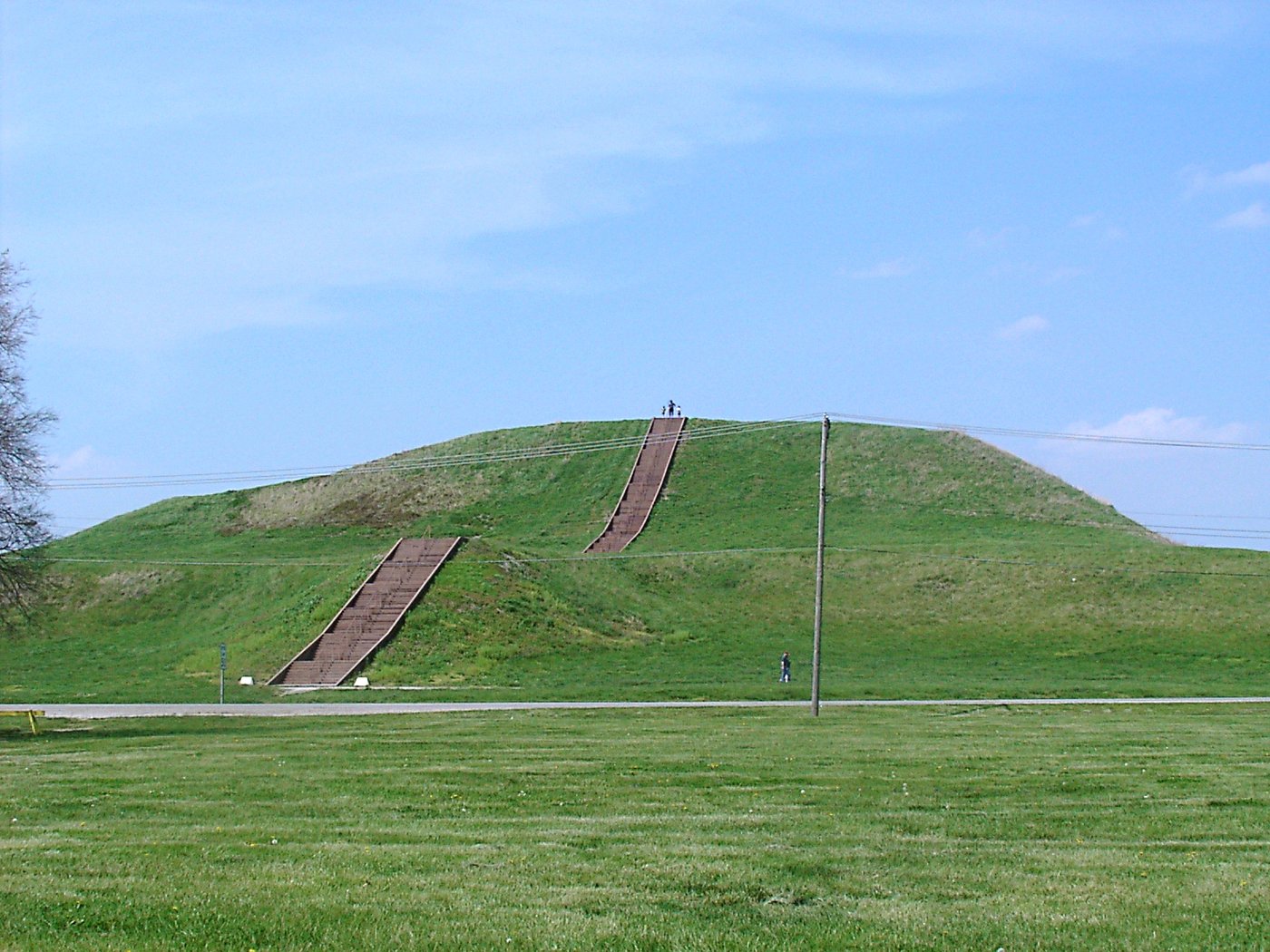
Stand at the foot of Monks Mound today and the numbers stop feeling abstract. It rises about thirty metres, ten storeys of packed earth, in a series of broad terraces. Its base covers close to six hectares, a footprint larger, on the ground, than the Great Pyramid of Giza. It is the biggest earthen structure in the Americas and one of the largest anywhere in the ancient world, and every basket of it was carried by hand. Estimates run to more than twenty million cubic feet of soil, dug with wooden and stone tools, hauled up the slope one load at a time in baskets weighing perhaps twenty-five kilograms each, over the better part of two centuries.
The name is another accident. A community of French Trappist monks settled on one of the mound's lower terraces around 1809 and kept gardens there for a few years before disease and hard times drove them off. They never built anything; they simply gave the mound the name it has carried ever since. On the summit, where the monks planted their vegetables, once stood a huge timber building close to thirty metres long: the seat, most archaeologists think, of whoever ruled the place. From up there a person could look out over the whole city and be seen from it.
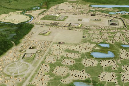
Monks Mound covers a larger area of ground than the Great Pyramid of Giza: roughly six hectares against the pyramid's five. The pyramid is far taller and made of stone; the mound is earth, and only about a third the height. But as a feat of moving material by hand, basket by basket, with no wheel, no draught animal and no metal tools, it belongs in the same conversation. And it was raised by farmers on a floodplain, not by a state with quarries and a standing labour force.
Not a scatter of mounds, but a plan
The mistake the early travellers made was to see the mounds as isolated curiosities. They were the frame of a designed city. In front of Monks Mound the builders levelled a vast open space, the Grand Plaza, around twenty hectares of ground flattened and filled to make it flat: a public square for markets, games and gatherings. Smaller plazas opened out to the north, south and west. Ranks of rectangular houses, wooden posts walled with mud and roofed with thatch, ran in ordered rows through the neighbourhoods around them. The whole plan was laid out to the cardinal directions, with a slight, deliberate offset that some researchers read as a nod to the movements of the moon.
Something remarkable happened here around the year 1050. In the space of a single generation the settlement was torn up and rebuilt on a grand scale: the plaza laid out, the big mounds begun, the population swelling as people moved in from across the region. Archaeologists sometimes call it Cahokia's “big bang.” At its peak, between about 1050 and 1150, the central city may have held ten to twenty thousand people, with more scattered through the farms and satellite towns of the floodplain. That made it the largest city north of Mexico, and by some measures a rival to the cities of medieval Europe. No settlement in what is now the United States would hold as many people again until Philadelphia, around the year 1800.
A calendar built out of posts
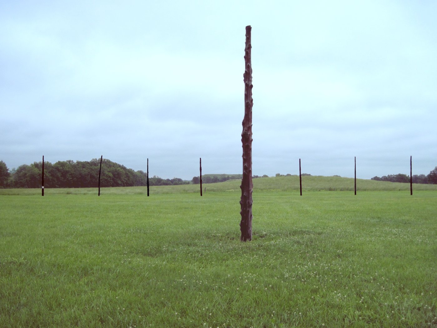
Not everything at Cahokia was made to last in earth. West of Monks Mound, archaeologists working ahead of a highway in the early 1960s noticed something odd in the soil: large post pits arranged in sweeping arcs. Warren Wittry worked out that they were the remains of great circles of upright timber, red cedar posts set in the ground and later pulled out or left to rot. The circles had been built and rebuilt several times, growing as they went; the largest held around forty-eight posts in a ring some hundred and twenty-five metres across. The nickname was inevitable: Woodhenge.
It was a calendar. From a viewing post at the centre, particular posts on the ring marked where the sun rose at the solstices and the equinoxes. At the spring and autumn equinox the sun came up in line with the front of Monks Mound, so that to a watcher at the centre it seemed to climb straight out of the great mound itself, the ruler's house catching the first light of the balanced day. For a farming people whose whole year turned on when to plant and when to harvest, a device that fixed the turning points of the sun was not decoration. It was infrastructure.
Mound 72 and the man on the falcon
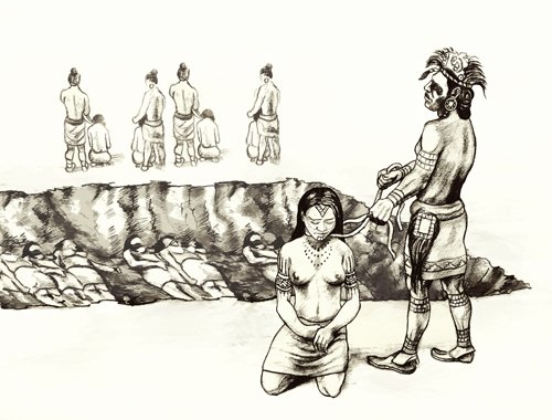
The gentlest reading of Cahokia does not survive Mound 72. It is a low, unremarkable ridge south of the great mound, and when Melvin Fowler dug into it in the late 1960s and 1970s he found it packed with the dead: around two hundred and seventy people, buried in some two dozen separate episodes. At the heart of it lay two men. One had been laid out on a blanket of shell: roughly twenty thousand marine beads arranged in the shape of a great bird, a falcon, with the body of the man as its body and the wings and tail spread around him. A second man was buried just beneath. Around this pair, in the same mound, were the others.
Some of those others are hard to read as anything but sacrifice. One pit held fifty-three young women, close in age, laid out in two tidy layers. Another held about forty people who had met a bad end: some decapitated, some with their hands cut off, a few, from the position of their bones, apparently not quite dead when the earth went over them, their fingers clawed into the sand. Between and around the burials the diggers found offerings on a scale to match: a rolled sheet of hundreds of finely made arrowheads, sheets of mica carried from the southern Appalachians, gaming stones, a heap of unused chunkey pieces. Mound 72 is the clearest window we have onto the power that ran the city, and what it shows is not gentle. Someone here commanded not just the labour of thousands but their lives.
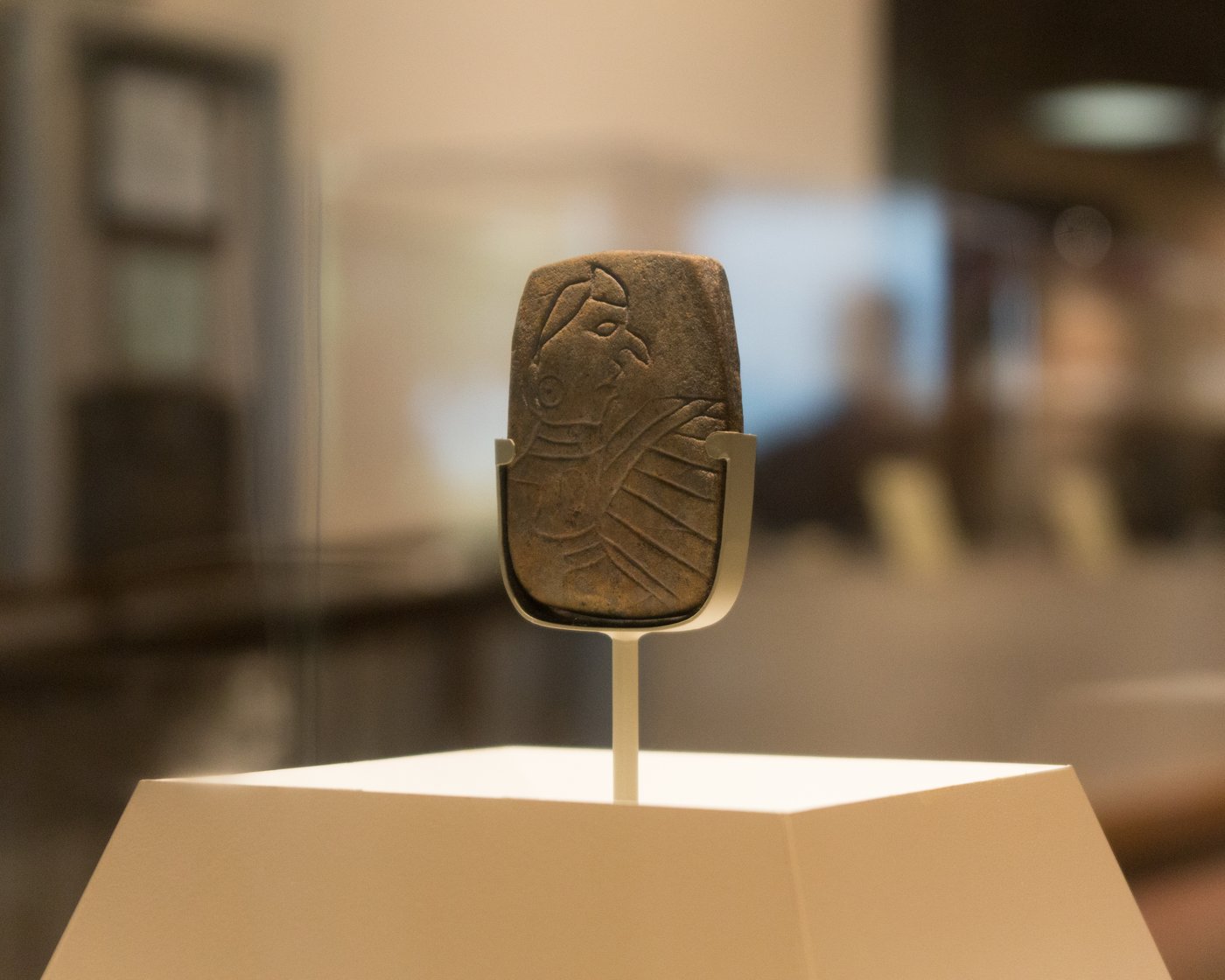
The bird was not a one-off. The falcon-man, the “Birdman,” runs all through the art of Cahokia and the wider Mississippian world: a warrior with a hawk's markings and wings, part man, part raptor, tied to the sky, to war, and to the game of chunkey. In 1971 a small red sandstone tablet turned up at the foot of Monks Mound with exactly this figure carved on one face and a pattern of scales, perhaps a snake's skin or feathers, on the other. The Birdman tablet has become a kind of emblem of the whole culture, the closest thing we have to a portrait of what these people thought a hero looked like.
Chunkey was the game whose stones fill the graves. A player rolled a polished stone disc across flat ground and the others hurled spears at where they guessed it would stop. It was played the length of the Mississippi valley, and it was more than sport: crowds bet heavily on it, and it seems to have carried real religious weight. Some archaeologists think Cahokia helped spread the game across half a continent, one more thread, alongside shared art and shared gods, that tied a scattered world back to this one city on the river.
Whose city it actually was
For most of the nineteenth century, educated Americans refused to believe that the ancestors of living Native people could have built any of this. The mounds were too grand, ran the argument, to be the work of “mere Indians.” So a whole mythology grew up around a lost civilisation of Moundbuilders (wandering Israelites, Phoenicians, stray Welshmen, Vikings, refugees from Atlantis), a superior people who had raised the mounds and then been slaughtered and driven out by the “savages” who came after. It was a convenient story. If the land's real builders had themselves been victims of Indian conquest, then removing the current inhabitants looked less like theft. Presidents and pamphleteers leaned on the idea while the tribes of the East were pushed west.
The mounds of the Mississippi were built by a vanished civilisation of superior outsiders (Israelites, Phoenicians, Vikings, some lost white race) who were later wiped out by the ancestors of today's Native Americans. The living tribes were latecomers, squatting on ruins they could never have made.
The mounds were built by Native Americans, the direct ancestors of nations still living. In the 1880s and 1890s Cyrus Thomas, working for the Smithsonian, dug through mound after mound and demolished the lost-race theory site by site, showing the earthworks were the work of local Indigenous peoples. The builders of Cahokia are linked today to the Dhegiha Siouan nations (the Osage, Omaha, Ponca and Quapaw among them), whose own histories reach back toward the great city on the river.
Why a city empties itself
Cahokia did not fall to an army or a volcano. It came apart slowly, and then it was simply gone. From about 1200 the population thinned. Neighbourhoods emptied, mound-building slowed and stopped, and by roughly 1350 the American Bottom, once the most crowded place north of Mexico, was close to deserted. When Europeans finally reached it, the fields stood empty and the mounds were silent. What drove people out has been argued over for a century, and the argument has taken some sharp turns.
One clue was already there in the ground: a wall. Around 1175 the Cahokians threw up a palisade of some twenty thousand logs, two miles of timber wrapping the central precinct, complete with bastions for archers. They rebuilt it four times. You do not wall a city that feels safe. Something (raiders, rival towns, unrest within) had made the people at the centre afraid enough to cut down a forest to hide behind.
Then there is the river. In 2015 a team led by the geographer Samuel Munoz pulled sediment cores from lakes in the floodplain and read the flood record written in the mud, layer by layer, back nearly two thousand years. The pattern was striking. Cahokia rose during a long, unusually dry spell when the Mississippi stayed low and the big floods held off: good, stable years for farming the bottomland. Then, around 1200, the great floods came back. A rise of many feet would have drowned the low fields the whole city depended on, again and again. The city's decline tracks the return of the water almost step for step.
Horseshoe Lake, an old channel of the Mississippi beside Cahokia, has been quietly filing a report for two thousand years. Each flood dropped a distinct layer of pale silt into its bed; each dry year left dark organic mud. By coring down through those layers and dating them, researchers reconstructed the river's moods across the whole life of the city: the flood-free window in which Cahokia boomed, and the return of destructive floods around 1200 as it began to fail. The same lake bed also holds faecal stanols, chemical traces of human waste, which rise and fall with the number of people living on its shore. Read together, the mud tracks both the water and the crowd.
Drought took its turn to be the villain too. Later work, some of it led by A. J. White, read chemical signals from the same lake beds and found the region tipping toward long, dry, evaporative conditions between about 1200 and 1400: hard years for maize just as the floods were also worsening, an unforgiving swing between too little water and too much. And for a long time a third story hung over all of it: that Cahokia had wrecked its own environment, stripping the uplands of timber for its palisades and houses until erosion and flooding did the rest. It was a tidy morality tale of a civilisation that consumed itself.
The old “ecocide” story, of Cahokia deforesting and flooding itself to death, has not held up well. Studies of the floodplain sediments have found little sign of the runaway erosion the theory needs, and evidence that people went on living in and around the region after the great mounds fell quiet. The likeliest picture now is not a single catastrophe but a pile-up: worsening floods, deepening drought, crops that failed too often, and a religious and political order that lost its grip. Faced with all that, people may not have been wiped out so much as they voted with their feet, leaving a place that no longer worked and carrying its stories, its gods and its games out into the wider world they became part of.
That last point matters more than any single cause. The people of Cahokia did not vanish. They dispersed. Their descendants are among the living nations of the midcontinent, and the falcon-warrior, the chunkey game and the earth-mound traditions carried on across the South and the Plains for centuries after the city on the river went quiet. Cahokia ended. Its people did not.
What the ground is still holding
The site you can visit today covers about two thousand acres and has been a UNESCO World Heritage Site since 1982. It preserves the greatest of the mounds and the reconstructed Woodhenge. But it is a fragment. Much of ancient Cahokia lies outside the fence: under the town of Collinsville, under subdivisions and warehouses, and under the interstate highways that run across the American Bottom on their way to the river. A good deal of it lies deeper still. Recent soil coring in the city's North Plaza has measured floodplain silt piling up at around five centimetres a year, burying the Mississippian ground surface some four metres down. In places the streets and house floors of the ancient city are simply underground, unexcavated, waiting.
Interest has not faded. In April 2025 two United States senators reintroduced a bill directing the National Park Service to study Cahokia and its outlying mound centres (the Emerald and Pulcher sites) for possible national protection; the measure was reported out of committee in early 2026. Archaeologists now work mostly without a spade, mapping what is left with ground-penetrating radar and coring rather than digging, careful with a place that is sacred to living people. Every season adds a little more to the picture and takes a little away from the mystery.
Brackenridge stood on the great mound in 1811 and counted the smaller ones spreading out below him, and the people he told called him a dreamer. He was not dreaming. The city he saw was real, it was built by the ancestors of people who were still very much alive, and it was larger and older and stranger than anyone in that young republic was willing to believe. Most of it is still there, under the corn and the concrete and four metres of river silt: the largest city of ancient North America, keeping, for now, the better part of its story to itself.
Read next: Poverty Point: The Colossal Mounds Nobody Was Ordered to Build and Chaco Canyon: The Desert City Built From 240,000 Trees Carried on Foot.
Sources & further reading
- Timothy R. Pauketat, Cahokia: Ancient America's Great City on the Mississippi (Viking, 2009).
- Melvin L. Fowler, The Cahokia Atlas: A Historical Atlas of Cahokia Archaeology (revised ed., 1997), on Monks Mound and the Mound 72 excavations.
- S. E. Munoz et al., “Cahokia's emergence and decline coincided with shifts of flood frequency on the Mississippi River,” PNAS (2015).
- A. J. White et al., work on drought, faecal stanols and population change at Horseshoe Lake (PNAS and related journals, 2019–2020).
- Cahokia Mounds State Historic Site and the UNESCO World Heritage listing (No. 198).
- Cyrus Thomas, Report on the Mound Explorations of the Bureau of Ethnology (Smithsonian, 1894), on the dismantling of the Moundbuilder myth.
Image credits (via Wikimedia Commons): aerial reconstruction of Cahokia — Heironymous Rowe / Herb Roe (CC BY-SA 4.0); reconstructed Woodhenge — QuartierLatin1968 (CC BY-SA 3.0); Mound 72 burial ceremony reconstruction — Herb Roe (CC BY-SA 3.0); the Birdman tablet — Paul Sableman (CC BY 2.0). Featured image: Monks Mound — Skubasteve834 (CC BY-SA 3.0).